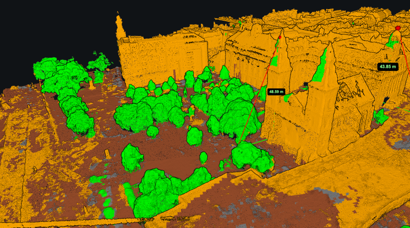
Switch a point cloud map from photo colours to classification colours and a familiar site can look quite different. The ground may become one colour, the trees another, and the buildings a third. These colours show labels assigned to the points, which can be used to select parts of the survey for further work.
The labels matter whenever you need to separate terrain from the objects standing on it. A roof included as ground can distort a terrain model. A real embankment removed with the vegetation can leave a gap in the very feature you wanted to survey.
Classification helps make those selections, but it still needs checking. A point labelled “ground” is a point the classification process has identified as ground, the label itself does not prove that the decision was correct.
What classification changes in a point cloud map
A point has a position in three dimensions and may also carry colour and other attributes. Classification adds a category describing what that point represents. Assigning a new category does not, by itself, move the point or improve its positional accuracy.
Although viewers often present classes like layers, they can be groups within the same file. A building class does not have to be a separate building file, and it is not necessarily a set of individual building objects. Likewise, a vegetation class may contain points from hundreds of trees without identifying which tree each point belongs to.
It helps to distinguish three operations:
Classifying assigns or changes labels on points.
Filtering selects points according to those labels or other criteria.
Colouring by classification displays the existing labels so you can inspect them.
A viewer that offers classification colours is not necessarily an editor or an automatic classifier. Changing the colour scheme also does not regenerate a terrain model that was produced earlier.
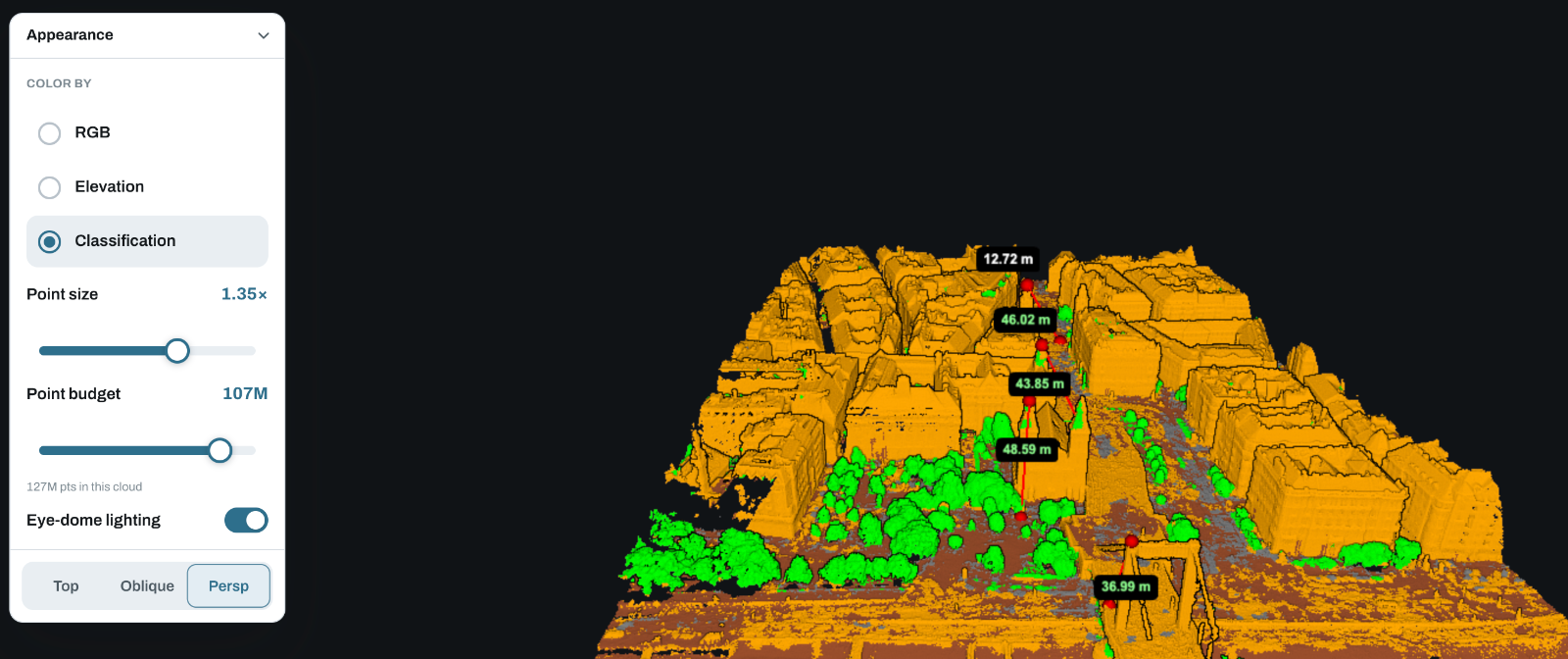
The classes you are likely to encounter
LAS and LAZ datasets commonly use numeric class codes based on the ASPRS LAS specification. Some familiar examples are listed below. The available codes depend on the file version and point format, and a particular survey may contain only a few of them. Esri's LAS classification reference provides a code lookup and explains the separate classification flags.
Class | Common LAS code | What it identifies |
|---|---|---|
Unclassified or unassigned | 1 | Points without a more specific assigned category |
Ground | 2 | Points classified as terrain |
Low, medium and high vegetation | 3, 4, 5 | Vegetation divided into categories |
Building | 6 | Points assigned to buildings |
Low point / noise | 7 | Low outliers or noise |
Water | 9 | Points assigned to water |
Wires | 13, 14 | Guard wires and conductors |
Bridge deck | 17 | Points on a bridge deck |
High noise | 18 | High outliers |
These are examples from the format, not a list of classes that every MapperTool output will contain. Check the classes actually supplied with your project and any accompanying description of how they were produced.
Ground: check the terrain it preserves
Ground classification is usually the starting point for creating a bare-earth terrain surface. The main concern is whether the selected points describe the terrain features needed for the job: the bottom of a ditch, the crest of an embankment, or the slope between two levels.
“Ground” does not necessarily mean natural, undisturbed soil. A surfaced yard or engineered earthwork may form part of the terrain surface, depending on the project's specification. If you need to distinguish existing terrain from temporary material, agree how stockpiles and spoil heaps should be treated. A general ground class may not make that distinction for you.
Inspect both what remains and what has been excluded. Removing building points is useful, but a large empty area beneath a removed building contains no new ground observations. Any continuous terrain surface across that gap must be estimated from the available information.
Vegetation: the class is not a tree inventory
Vegetation classes can help separate plants from terrain and structures. Low, medium and high vegetation should be interpreted using the dataset's classification rules; do not assume every provider uses identical height thresholds.
A class for high vegetation does not tell you the species, condition or individual height of every tree. Those questions need additional analysis. Even a tree-height calculation needs a ground reference, which may be poorly represented beneath a dense canopy.
In a cloud reconstructed from photographs, hiding the vegetation will not expose ground that the camera could not see. This is particularly relevant when a result looks complete in its original colours: the canopy may be dense while the terrain beneath it is almost absent.
Buildings and structures: inspect the edges
Building points can be useful when separating roofs and walls from surrounding terrain. Pay attention around eaves, adjoining trees and low extensions, where the transition between objects is less clear than it is across the middle of a roof.
Labels also follow the chosen classification scheme. A flat surface high above the ground could be a roof, a bridge deck or part of another structure. Its intended category cannot always be resolved from height alone.
For an inspection project, you may need those structural points even if they are excluded from a terrain workflow. Keep the original cloud available so a selection made for one purpose does not remove information needed for another.
Wires, water and noise: a label does not fix weak geometry
The existence of a wire class in the file format does not mean thin cables were captured successfully. A photographic reconstruction may contain incomplete or noisy points around them. Assigning a wire label cannot turn those points into a complete cable survey.
Water needs similar care. Reflections and movement can make photographic reconstruction unreliable; a water label is not evidence that the cloud measures the water surface accurately, and it says nothing about the bed beneath it.
Noise classes identify points intended to be excluded from relevant analysis, but review unusual features before discarding them. An isolated point far above a roof may be an error. A narrow cluster belonging to an actual pole or antenna may simply be small compared with the surrounding surfaces.
How automatic ground classification works
Different methods use different combinations of local height, slope, surface shape and neighbourhood relationships. A ground filter generally tries to separate the terrain from objects above it, using assumptions about how the terrain changes across the site.
For a concrete example, PDAL's Simple Morphological Filter documentation exposes controls for cell size, slope, elevation threshold and window size. It classifies ground points and can leave other points unclassified. A ground-filtering step therefore need not distinguish trees from buildings or identify every object in the scene.
Those settings also explain why one automatic pass may work better on an open field than around steep cuttings or large structures. This is a general example of ground classification, not a description of MapperTool's internal processing algorithm.
Consider a small development site with a warehouse, a steep access ramp and trees along a ditch. A filter needs to reject the warehouse roof while retaining the ramp as terrain. Around the trees, it must work with whatever ground points were actually captured. Changing the settings may improve one part of the site while making another worse, so a clean-looking overview is not enough to judge the result.
A practical review before using the classes
Start with the intended output. For a terrain model, prioritise the ground selection. For a building inspection, prioritise the walls, roof edges and nearby objects. This keeps the review focused on errors that would affect the work.
Compare the labels with the original scene. Look at photo colours alongside classification colours, and refer to source photographs where a surface is ambiguous. Concentrate on boundaries: vegetation beside walls, low roofs near rising ground, and banks around excavations.
Look from the side as well as above. A strip of wrongly labelled points can be hard to notice in plan view. In a side view or a cross-section, it may appear as ground floating above the surrounding terrain or a missing strip across a slope. Use software with suitable section tools when a detailed review calls for them.
Inspect the ground selection for coverage. Where your software allows class filtering, view ground points on their own. A small gap between nearby terrain points has different implications from a broad gap beneath trees. Check how any later surface-generation step handles those gaps.
Resolve errors before creating dependent outputs. If correction is needed, use a classification editor or revisit the processing workflow. Keep a record of material changes and regenerate affected terrain outputs. Recolouring the point cloud does not update an existing DTM.
What this means for a DTM
A digital terrain model represents a continuous ground surface. Classified ground points can provide observations from which that surface is constructed, but there are still decisions about interpolation, grid spacing and unsupported areas.
Two different problems can therefore produce a poor DTM. Incorrect labels may include a shrub or roof as terrain. Alternatively, the labels may be correct but there may be too few ground observations to describe a ditch or slope. Correcting the first problem requires better classification; the second may require additional survey data.
If you are choosing between surface and terrain outputs, our guide to what a digital terrain model represents explains the distinction. Classification is one part of that workflow, not a substitute for checking the finished surface.
Inspecting classification in MapperTool
MapperTool's point cloud viewer offers RGB, elevation and classification colouring. Select classification to inspect the groups present in your result, then return to RGB when you need visual context. The point cloud viewer documentation describes these display options.
Use elevation colours for a different question: how high the points are. Points at similar elevations can belong to different objects, so a height colour scheme should not be read as a classification result.