A client sends a site boundary and asks for an elevation model. Before planning a flight, spend a few minutes checking whether free digital elevation models already cover the area.
For a first look at a landscape, an existing dataset may be all you need. For a stockpile that changed yesterday, even excellent public data can describe the wrong site. And for ground beneath trees, a suitable existing lidar survey may answer a question that fresh drone photographs cannot.
The useful comparison is between the data and the job. Start with what must be measured, how recently it must have been captured, and how much uncertainty the decision can tolerate.
Start with the question in this table
What you need | Where to start | What would justify new data |
|---|---|---|
Broad terrain context around a proposed site | A global elevation model | The decision depends on small local features the grid does not resolve |
Ground shape across an established site | A public lidar DTM, where available | Earthworks or other ground changes since capture |
Current stockpile volumes | A recent survey of the pile and a suitable base surface | Material has moved since the last usable survey |
Current roof and structure heights | A recent surface model with adequate detail | Buildings are missing, outdated or poorly resolved |
Ground under woodland | A suitable lidar terrain dataset, with its quality information | Ground coverage is inadequate; a different capture method may be needed |
Change between two reporting dates | Two surveys with compatible references and adequate accuracy | Existing data does not represent one of the required dates |
An available download is a candidate. It becomes usable when its specifications support the measurement you intend to make.
Where to find free digital elevation models
Copernicus DEM: a global starting point
The Copernicus DEM includes global GLO-30 and GLO-90 products, with nominal spacing of 30 and 90 metres. It represents the surface, including vegetation and structures, rather than a ground-only model. The main TanDEM-X acquisition period was 2011–2015, with other sources used to fill gaps.
That makes it worth checking for broad landscape context. It does not make it a current survey of a construction site. Public access to the global products is available through the Copernicus Data Space Ecosystem; follow the current registration and access instructions on the official Copernicus DEM page.
England: check the Environment Agency lidar data
Free data is not always coarse satellite data. The Environment Agency publishes a 1 m lidar composite DTM covering approximately 99% of England. It is a bare-ground product, making it a different starting point from a global surface model.
The composite combines surveys from different dates. Check the survey index for the actual location instead of treating the catalogue update date as the flight date. The official dataset listing links to downloads and metadata.
United States: USGS 3DEP
For US sites, the USGS 3D Elevation Program is another starting point. Its products include bare-earth elevation models at several resolutions, including 1 m data where available. Check the coverage and acquisition information for the project area through the USGS product guide.
Elsewhere, look for the national mapping agency or regional open-data catalogue. Search for both DSM and DTM products: the file with the finest grid may still contain the wrong surface for your question.
Read these four details before using a tile
1. Which surface does it describe?
A digital surface model includes the tops of objects. A digital terrain model represents the bare ground. Choose between them by what the job needs to measure.
A roof belongs in a model used to assess obstructions. It does not belong in a model intended to describe the ground beneath that building. The name “DEM” alone may not settle which you have. Read the product description, and use the distinction explained in orthomosaic, DSM and DTM to choose the layer.
2. When was this part of the site captured?
Download date, release date and acquisition date answer different questions. A recently published composite may include older surveys. On unchanged ground that may be acceptable. On a quarry face, a construction site or a recently regraded yard, it can invalidate the measurement before you open the file.
3. What detail and accuracy does it support?
Grid spacing tells you how closely elevation samples are arranged. It does not tell you how accurate their heights are. A one-metre grid is not a promise of one-metre vertical accuracy, and a finer export does not recover features absent from the source.
Read the accuracy statement and the method behind it. When comparing against a new drone survey, keep the same distinction between resolution and accuracy; it is covered in drone survey accuracy explained.
4. Can it be used alongside the other project data?
Check horizontal coordinates, height reference and units before combining surfaces. Also read the provider's reuse and attribution terms before including the data in a client deliverable. Keep that information with the downloaded tile so the next person can trace where it came from.
A small example: the ditch beside the yard
Suppose the question is whether a two-metre-wide ditch remains open beside a storage yard.
With a nominal 30 m grid, the ditch width is only about one fifteenth of the sample spacing. The dataset cannot reliably describe its cross-section. Resampling that grid to 10 cm would create more values between the existing samples, without adding observations of the ditch.
A 1 m terrain model gives you more to work with, but a feature only a couple of cells wide still needs caution. Its capture date matters too: a delivery of aggregate last week may have blocked a channel that was clear when the public survey was flown.
A new survey is useful here if it can actually observe the ditch and meet the required accuracy. Dense vegetation or standing water may call for ground measurements or another method. The reason to collect new data is specific: the existing model cannot establish the present condition of the feature.
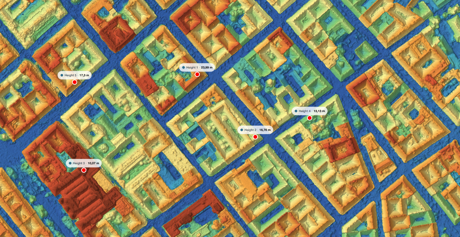
When drone elevation mapping earns its cost
There are three strong reasons to fly: the site has changed, the existing data does not resolve what matters, or the job needs a repeatable record for a particular date.
Define the deliverable before setting the flight height. A progress overview, a pile volume and a height measurement have different requirements. State what must be visible, what accuracy is needed and how you will check the result. Then plan the imagery around those requirements.
There is a limit worth keeping in view. New photographs do not reveal ground hidden beneath a closed canopy. MapperTool's DTM documentation explains that terrain in areas with little visible ground is interpolated. A fresh image set can therefore produce a detailed canopy surface while leaving the ground question unresolved.
If your existing data already answers the job, use it. If you need a current model of an observable site, MapperTool can process your geotagged photographs into elevation outputs that you can inspect in the browser. The documentation describes the workflow from upload to results.
Need a current model of your site? Upload your drone photos and choose the elevation outputs your job requires.