Every drone mapping project produces the same three files, and every week someone hands a client the wrong one. The orthomosaic looks like a photo, so it gets used to measure a roof height. The DSM is a height map, so it gets used to plan a driveway. Neither works, and the mistake usually only surfaces after the client has already acted on the wrong number.
Photogrammetry software rarely explains the difference on its own. Below is the plain answer: what an orthomosaic, a DSM and a DTM each actually contain, why they look similar but answer completely different questions, and which one to hand over for a given job.
Key takeaways
An orthomosaic is a geometrically corrected photo. It carries no height information.
A DSM includes buildings, trees and vehicles. A DTM is the bare ground underneath them.
Volume and cut and fill work need a DTM base and a DSM surface. Roof and area work need the orthomosaic.
All three come from one flight, so the real decision is what you hand over, not what you fly.
What an orthomosaic actually is
An orthomosaic stitches hundreds, sometimes thousands, of overlapping drone photos into a single image where every pixel is viewed straight down, at a known ground sample distance. Because the perspective distortion and terrain displacement are removed during processing, you can measure distances and areas directly on it, the same way you would on a paper map. What you cannot do is read a height from it: the elevation data was used to build the image and then discarded, so the pixel values are only colour.
For most clients this is the deliverable they instantly recognise. It opens in any GIS, it drapes over Google Earth, and it prints at high resolution for a site meeting. The trade off is that its usefulness stops exactly where height questions start.
A word on resolution. The orthomosaic inherits its detail from the flight, not from the export setting. If you flew at a ground sample distance of 3 cm/px, exporting the ortho at 1 cm/px produces a bigger file with no extra information in it.
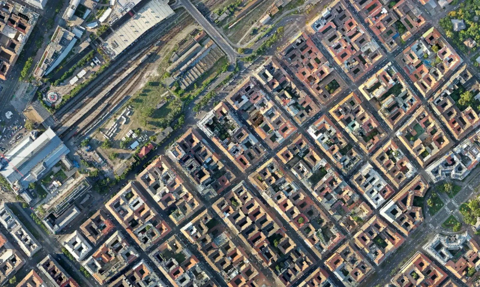
DSM vs DTM: the one sentence difference
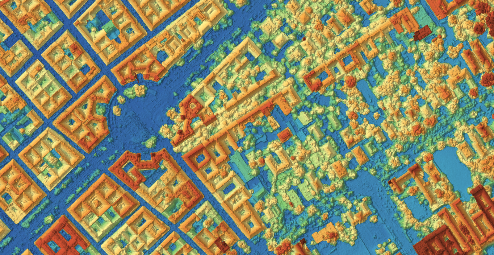
The digital surface model is the elevation of the top of everything the camera saw: roofs, tree canopies, parked machinery, stockpiles. The digital terrain model is the elevation of the bare ground, with everything sitting on top of it removed. That single sentence decides most of the choice between the two, and it is worth reading twice before opening either file.
Both are single band rasters. Each pixel holds one number, an elevation in metres, and the colours you see in a viewer are a ramp applied to those numbers, not part of the data. That is why a DSM looks like a strange heat map until you turn on a legend or a hillshade.
Where the DTM comes from
Unlike the DSM, which comes directly from the reconstructed point cloud, the DTM is derived, not measured. A ground classification step labels each point as ground or non-ground, then interpolates the surface underneath the points that were removed. Under dense canopy, inside a stockpile yard or across a large warehouse roof, that interpolation is closer to an educated guess than a measurement. Treat it as one when you hand it to a client. A quality report that flags low ground point density in these areas is worth more than a DTM that looks smooth but hides the gap.
Which output answers which question
Before opening any file, it helps to know which question you are actually trying to answer. The table below is the short version of a conversation that otherwise takes twenty minutes on a call.
Not sure which one your site needs?
Upload the photos once and get the orthomosaic, DSM and DTM from the same flight. The free plan takes up to 150 photos per project.
Upload drone photosOutput | The question it answers | Typical use | File |
|---|---|---|---|
Orthomosaic | What does the site look like, and how large are things? | Progress photos, area take offs, site plans | GeoTIFF or JPG, RGB |
DSM | How high is the top of everything on site? | Stockpile volumes, roof heights, line of sight | GeoTIFF, single band, metres |
DTM | How high is the bare ground? | Cut and fill, drainage design, contour lines | GeoTIFF, single band, metres |
When you need all three at once
Stockpile and earthworks jobs need a DTM for the base surface, a DSM for the pile itself, and the orthomosaic so the client can see exactly where the pile boundary was drawn before trusting the volume number.
[Insert image here: A stockpile volume measurement: the DSM surface, a drawn boundary and a DTM base combine into one defensible number.]
Roof inspections rarely need the DTM at all, since the ground underneath the building is not the point. Agricultural clients typically want only the orthomosaic, and, if the sensor supports it, a vegetation index layered on top of the same flight.
A quick way to check your work
Before sending a volume or elevation number to a client, switch between the DSM and DTM in the viewer and check that the difference makes sense. Near zero on bare ground. A clear step at every building and tree line. A smooth, plausible surface anywhere the ground classifier had to guess. If a flat parking lot shows a metre of difference between the two layers, something in the classification step needs a second look before the report goes out.
What about the point cloud?
All three of these rasters are built from the same intermediate product: a dense 3D point cloud. The cloud is the measurement, the rasters are convenient projections of it. If the client wants to inspect a facade, a gantry or anything that a top down raster flattens away, the cloud is the file to send instead.
File formats and coordinate systems
GeoTIFF is the safe default for all three raster outputs. It carries the georeferencing inside the file, so the client does not need a sidecar world file, and it opens in QGIS, ArcGIS, AutoCAD Civil 3D and every other package a surveyor is likely to have.
The one thing worth agreeing before delivery is the coordinate reference system. A file in WGS 84 UTM will not line up with a client's local grid until someone reprojects it, and that someone should be you, not the person opening the email. Ask which EPSG code their existing drawings use, set it at processing time, and the deliverable drops straight into their project. If they cannot tell you, a UTM zone is a reasonable default and easy to convert later.
Frequently asked questions
Can I measure a building height directly on an orthomosaic?
No. The orthomosaic has no height channel, only colour. Open the DSM in the viewer and use the point or height measurement tool, or trace the roof outline on the orthomosaic and read the elevation from the DSM at the same location.
Is a DTM accurate under trees and dense vegetation?
Only approximately. Under a closed canopy the camera never sees the ground, so the DTM is interpolated from whatever ground points exist at the edges of the vegetation. Treat DTM values under dense canopy as an estimate, and say so when the terrain there matters to the client's decision.
Which file format should I hand over to a client?
GeoTIFF for all three outputs is the safest default: it opens in every major GIS and CAD package without conversion, and it keeps the georeferencing intact. Add a JPG export of the orthomosaic only when the client needs something light to drop into a slide deck.
Is a DEM the same thing as a DTM?
In everyday use, yes. Digital elevation model is the umbrella term, and most people mean bare earth when they say it. Because the word is ambiguous, name the file DTM or DSM explicitly in the delivery, and state in one line which one it is. That single sentence prevents most of the confusion this article is about.
The orthomosaic, the DSM and the DTM come from the same flight, but they are not interchangeable. Treating them as if they were is the fastest way to hand a client a wrong number with total confidence. Once the one sentence difference between a surface and a terrain model is clear, picking the right file for a given job stops being a judgment call and becomes a lookup. If you want to check how many outputs and how long a project stays available on each plan, the details are on the pricing section.