

Auto Count by MapperTool
Count objects in drone maps.
Review every result.
Turn your aerial survey into a count you can check. Find cars, trees and buildings, inspect each detection on the map, and correct the result before you share it.
From €15/month
€180 billed annually.
- Automatic detection
- Editable results
- Located on your map
Start with your drone images
Process an RGB orthomosaic and DSM first. Auto Count runs on the finished project and requires an eligible subscription.
The flight is only the beginning
A total is hard to trust when you cannot check the objects.
Counting by hand is only part of the job. You still need to catch omissions, resolve duplicates and explain the number to the person who will use it.
Another count. Another check.
Working across a large map makes it easy to lose your place. A changed boundary can mean checking the same area again.
Missed or counted twice?
A spreadsheet total does not show which car, tree or building contributed to it. Reviewing the map gives you that context.
A client asks: which objects?
Give them more than a number. Keep the locations behind the count so you can return to a specific finding.
Make the count easier to explain.
Start with automatic detections, then use your judgement where the imagery needs a closer look.
One module. Different surveys.
What do you need to count?
Choose one object category for each run. Start with a clear aerial view of the objects you want to find.

Cars
Locate vehicles visible in your survey. Review parking areas and streets at the time the images were captured.

Trees
Find visible tree crowns and inspect the detections. Overlapping crowns and dense canopy need careful review.

Buildings
Create a mapped starting point for a building count, then check boundaries, small structures and false detections.
Also supports bales, solar panels, material stockpiles and plantation plants. Suitability depends on object size, visibility and imagery. Crop-specific results need validation.
A real survey. Right here.
Explore the map behind the count.
Explore 33 car markers in a reviewed crop of the Thermal demo project. Zoom into the street, select a car and inspect its position.
Thermal demo project
RGB map · Reviewed car markers
33 markers shown
Drag to pan. Use + and - to zoom, arrow keys to move, and 0 to reset. Use the selector or previous and next buttons to inspect detections.
The markers in this preview were manually reviewed and corrected against the RGB imagery. This is a corrected example, not an unedited automatic result.
Automatic detection. Your judgement.
Keep control of the final count.
The first result is a starting point. Review the image beneath each marker and make the corrections your project needs.
Inspect the finding
Select an object and return to its location. Compare each marker with the imagery.
Correct the result
Add a missed object, move an incorrect point or remove a false detection in your own project.
Keep the corrected geometry
Export the reviewed locations as GeoJSON for the next step in your workflow.
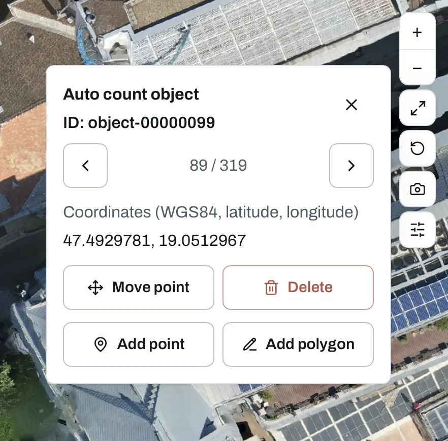
Object review in MapperTool. Changes are made in your project, not in this public preview.
Compare the investment
Compare the workflow. Then compare the price.
Choose the tools and capacity your work needs. These annual subscriptions cover different workflows and usage limits.
MapperTool · Plus
€180/year
Equivalent to €15/month, billed annually.
Drone processing, Auto Count, map review and project sharing in one browser workflow.
900 images per project · 30 days of project access
See plansAgremo · Starter AI
$349/year
Annual agricultural analysis package
Up to 10 maps and 30 AI analyses across 10 fields, including stand count and plant-health analysis.
Agremo pricingSolvi · Starter
€1,499/year
Annual crop-monitoring subscription
1,500 credits per year. Each upload includes 10 ha of basic plant counts, with additional usage charged in credits.
Solvi pricingAnnual list prices checked 4 Nov 2026. Currencies, features, limits and taxes vary.
From drone images to a count you can review.
Bring the survey. Keep processing, counting and delivery in one place.
- 01
Upload & process
Upload overlapping RGB drone images and generate an orthomosaic and DSM.
- 02
Choose & count
Open Auto Count on the completed project, choose a category and start the analysis.
- 03
Review & correct
Inspect detections on the map and adjust the result where needed.
- 04
Export & share
Export corrected GeoJSON and share the project map with your client.
A result your client can use
Give them the map behind the number.
Object locations keep the count connected to the survey. Share the project for visual review, or take the corrected geometry into your next tool.
- A map with individual object locations
- A share link for project review
- Corrected GeoJSON for GIS workflows
Before your next flight
Clear imagery makes a better starting point.
Auto Count analyses a processed drone survey. It is not a counter for arbitrary phone photos or live traffic video.
A finished project with an RGB orthomosaic and DSM
Enough image detail to distinguish the objects
Visible objects with limited overlap and obstruction
An active plan that includes Auto Count
Shadows, small objects, dense foliage and reconstruction artefacts can affect detections. Review the result before using the count.
Prepare your drone imagesStart with the capacity you need
Your next count starts here.
Every plan below includes Auto Count. Compare image limits, project access and the other tools included.
Start with Plus
Choose the entry plan for smaller projects. Move up when you need more images, longer access or additional modules.
Modules
- Auto countBeta
Modules
- Solar InspectBeta
- Auto countBeta
Want to inspect the result first?
Open the full demoBefore you start
Practical answers about drone object counting, reviewing results and choosing a plan.
Get more from your next survey
Prepare drone maps for Auto Count
Plan the imagery and outputs your analysis needs.
Count trees and bales on farm maps
Explore counting in an agricultural survey.
Auto Count documentation
Check supported objects, review controls and exports.
Turn your next survey into a count you can check.
Let automatic detection do the first pass. Keep the final result in your hands.